Snow Advanced Course
Mountain Education is a non-profit Wilderness School founded in 1982 by Ned Tibbits. Ned thru-hiked the PCT in 1974.
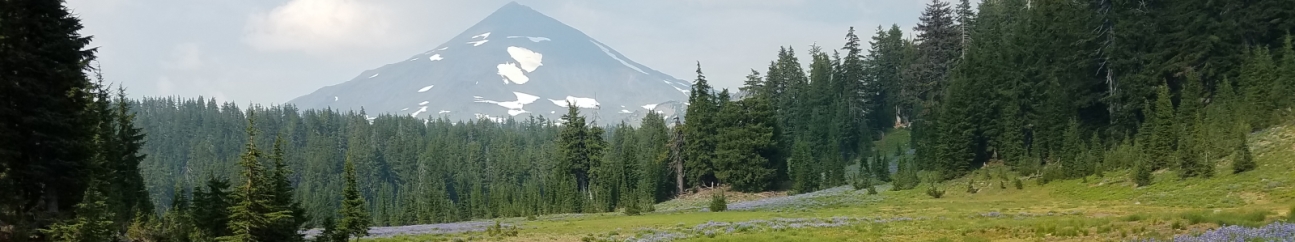
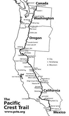
It’s currently early in the winter season but the Sierras, along with much of the west, have been getting pounded with snow. Some areas have close to twice as much snow than average for this time of year. My experience hiking in snow is pretty limited. 30 years back I did some snowshoe backpacking in Vermont and I’ve winter camped a few times but I’ve never been in high elevation mountains with deep snow and real dangers. In a below average snow year (like the last 4 have been) I would face snow at least on the north slopes above 10,000 feet. This year may be way above average so I just signed up for the Snow Advanced Course for PCT thru-hikers. The instructors meet you on the PCT about 45 miles north of Kennedy Meadows. This is right before the highest, snowiest and most difficult passes. The instruction then takes place while you hike north, take a day off the PCT to summit Mount Whitney (14,505′), then continue north over Forrester Pass and finally off the PCT over Kearsage Pass to head way down into Lone Pine for resupply. I’m scheduled for the class starting on 6/4. If I can’t make that one, the fallback date is 6/12.
Here’s the course description and itinerary:
You will meet Mountain Education’s Snow Skills Instructor and start your SAC course at Chicken Spring Lake just west of Cottonwood Pass the night before your trip begins. He or she will have just come up from a resupply at the DeLaCour Ranch in Lone Pine via Cottonwood Pass from the Horseshoe Meadows trailhead.
For each of the next 6 days, you will hike slower to learn with your group as we stop often to discuss and point out various aspects of safe, over-snow, wilderness travel and teach specific snow skills to keep you Risk-Aware. The many details we will discuss or demonstrate are:
- How to find and follow a trail buried in the snow above timberline,
- Safe and Efficient Route Selection, independent of the trail,
- How to find “trail sign” in the woods to know where the trail is located,
- Personal Safety & Enjoyment = Wilderness Awareness,
- How to walk on snow without slipping, falling, postholing, or even getting wet,
- Ascent, Descent, and Traverse skills on steep snow,
- Self-Arrest, Glissading, Boot-Skiing, and Heel-Plunge techniques,
- How to find and get water from a lake or creek without falling in,
- Where and how to hike and camp on snow and still stay warm and dry,
- Topographical Navigation on volcanic, magnetic surfaces without a compass,
- Hypothermia, Frostbite, Exposure, Dehydration, Altitude Sickness, Trail Trauma/Illness, etc
- How to use Hiking-Crampons and a Whippet Self-Arrest Pole,
- Avalanche Awareness and Avoidance,
- How to make wise wilderness travel decisions in the middle of nowhere,
- Maintain the Rules of the Trail, and
- Emergency Communications, Search & Rescue, and Wilderness Medicine.
Section Four: Course Itinerary
Day-1:
Remember, we move over-snow slowly to avoid injury and spend time teaching what you need to know and do. This may be a big change from the daily mileage you’ve gotten used to from Mexico on up the trail. Believe us, do not go fast through the snow-covered Sierra! It is too beautiful and dangerous a place to be hasty. Pick up your speed again whenever on dry-trail and keep an eye on your schedule so you get to Canada before mid-September (to avoid getting caught on-trail when the new powder snow arrives!)
On the evening before day-1, after we meet, pitch our tents, and maybe have dinner, there will be an equipment inspection to make sure you brought the required gear for what we teach.
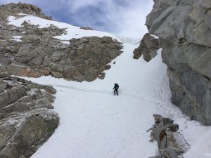
The morning of day-1, if the weather allows, we will teach you your steep snow skills (ascending, descending, and traversing) to prevent slip and falls, then how to self-arrest to stop them. This will be a quick clinic requiring full waterproof shells, top and bottom (rain pants may do, but they must be durable as sitting or sliding on crusty snow or ice may tear them), gloves, glasses, gaiters and a sense of humor! If it is decided that conditions are not favorable to conduct this clinic at this time, it will be taught at the next available, safe, and appropriate time and location during the trip.
This day we enter Sequoia National Park just west of Chicken Spring Lake near a little lake at 11,200, descend briefly to go across or around Siberian Outpost, then drop into Rock Creek where we will camp for the night (10.1 miles). For fun, go to the Mountain Education You Tube Channel to watch videos 4.132, 133, 134, and our second long-distance Navigational tutorial, 4.138. Most of this day is about Macro & Micro Navigation and learning to stay hydrated and fueled amidst tremendous exposure of sun and wind on snow.
Day-2:
Begins with a creek crossing of normally benign (pre-thaw) Rock Creek (YouTube 5.149). Now, since we are beneath the treeline, on snow, and can’t see the high landmarks needed for accurate visual topographic navigation, we will have to remember the route north from our views yesterday. Today, we will climb out of Rock Creek, teaching you that you do not have to be on the trail to follow it, traverse near the eastern, avalanched side of Mt. Guyot to summit Guyot Pass, cross Guyot Flat with its incredible view westward toward the Triple Divide, and drop into famous lower Crabtree Meadow where we will intersect with a John Muir Trail alternate. We will have lunch there, basking in the sun on large, hot slabs of granite after making our first creek wade. After lunch, we will head up Whitney Creek a few more miles to establish our Whitney climb basecamp near Guitar Lake (11,500).
Day-3:
Today is a day off from northward progress, but it is when we climb Mt. Whitney! It begins with a lesson on route selection choices up to Trail Crest (13,500) that includes a practical, on-the-hill assessment of the safety of the route, the weather, and each individual hiker’s abilities. Those who do not want to make the journey to the top do not have to and can enjoy the zero day in camp. If the route or weather are deemed unsafe, we will enjoy the day off and otherwise explore the high alpine environment.
We will cut our own switchbacks up to Trail Crest, ascending nearly 2,000 feet up an exposed, snow-covered wall of granite slabs and boulders, look down onto the town of Lone Pine, nearly 9,000 feet below us, then turn north and follow the ridge up another 1,500 feet to the summit. There we marvel at the view, sign the trail register, explore the old stone observatory built in 1909 by the Smithsonian Institute, try to stay warm, eat and drink as much as we can, take lots of pictures, then begin our 3500-foot descent. This climb takes a bit out of everyone, so when we get back to our basecamp, we eat dinner and call it “quits” for the night!
Day-4:
Returning the 4 miles back down to the PCT/JMT, we continue our journey north, up and out of Whitney Creek to Sandy Meadow, through a low saddle, and steeply down through trees on a snowy (early season), northern aspect to teach our first whitewater crossing at Wallace Creek. Drying out on the other side, we’ll enjoy our lunch, hopefully in the sun, then climb up the ridge between Wallace and Wright creeks to a terrific overview where we often take a group picture. After a few steps, we arrive at our second whitewater crossing at Wright Creek, put on our creek crossing shoes to do it, change shoes back to our hiking boots on the other side, and wander amidst wind-torn pines up to famous Bighorn Plateau (11,400) and its incredible 360-degree views. It is a windy place, however, so we may just hurry along and make a descending traverse beneath Tawny Point to cross our third whitewater creek, Tyndall Creek and find a killer campsite for the night on the other side.
This day is all about navigating up, down, and across creek drainages where we utilize our distant views from the ridges, remembering them to find our way when down below timberline in the creeks, and about creek crossings, which may or may not be flowing high and wild because of a thawing snowpack. On colder visits, we will take advantage of the presence of snow bridges across these creeks, affording us dry and easy crossings (extensive clinic on assessing snow bridges). We discover, also, that in the warm afternoons, the snowpack may get ridiculously soft, meaning we will be learning how to recognize and avoid postholing conditions and the sub-surface hidden hazards that exist within the snowpack which can lead to injuries and fatigue.
Day-5:
This day we start very early (0500-0600) to both utilize the cold, hard morning snow for easy walking and to get up and over 13,200-foot Forester Pass before the snow softens and we start postholing on the northern descent! The obvious lesson of this day is the ascent and descent of Forester Pass (13,200) under springtime, consolidated snow. Extensive clinics on ascent, descent, and traversing techniques, to include self-arrest, glissading, and risk recognition will happen, again, at the base of the climb. Make sure your cameras are working because this is one awesome day! After a glorious slide down the north side of Forester, we make a long traversing descent on and off snow past Center Basin Junction (10,500) and down picturesque Bubbs Creek to Vidette Meadow and our camp. This is our last night together, so it is not uncommon for us to enjoy a large campfire here to celebrate all we’ve learned!
Day-6:
Having mastered our above & below timberline navigational skills to the point where we don’t even worry any more about being right on the trail all the time, we begin this day early with an abrupt but quick climb up and out of Bubbs Creek to the Charlotte Lake/Kearsarge Pass junction, then our departure from the PCT as we turn east, snow-hike over Kearsarge Pass, and steeply descend to the Onion Valley TH below. This day, each student will lead the group, picking their own path over-snow, a great lesson in leadership and independent planning.
This scares me, please stay home! I’m thankful you’re getting yourself well-trained.